
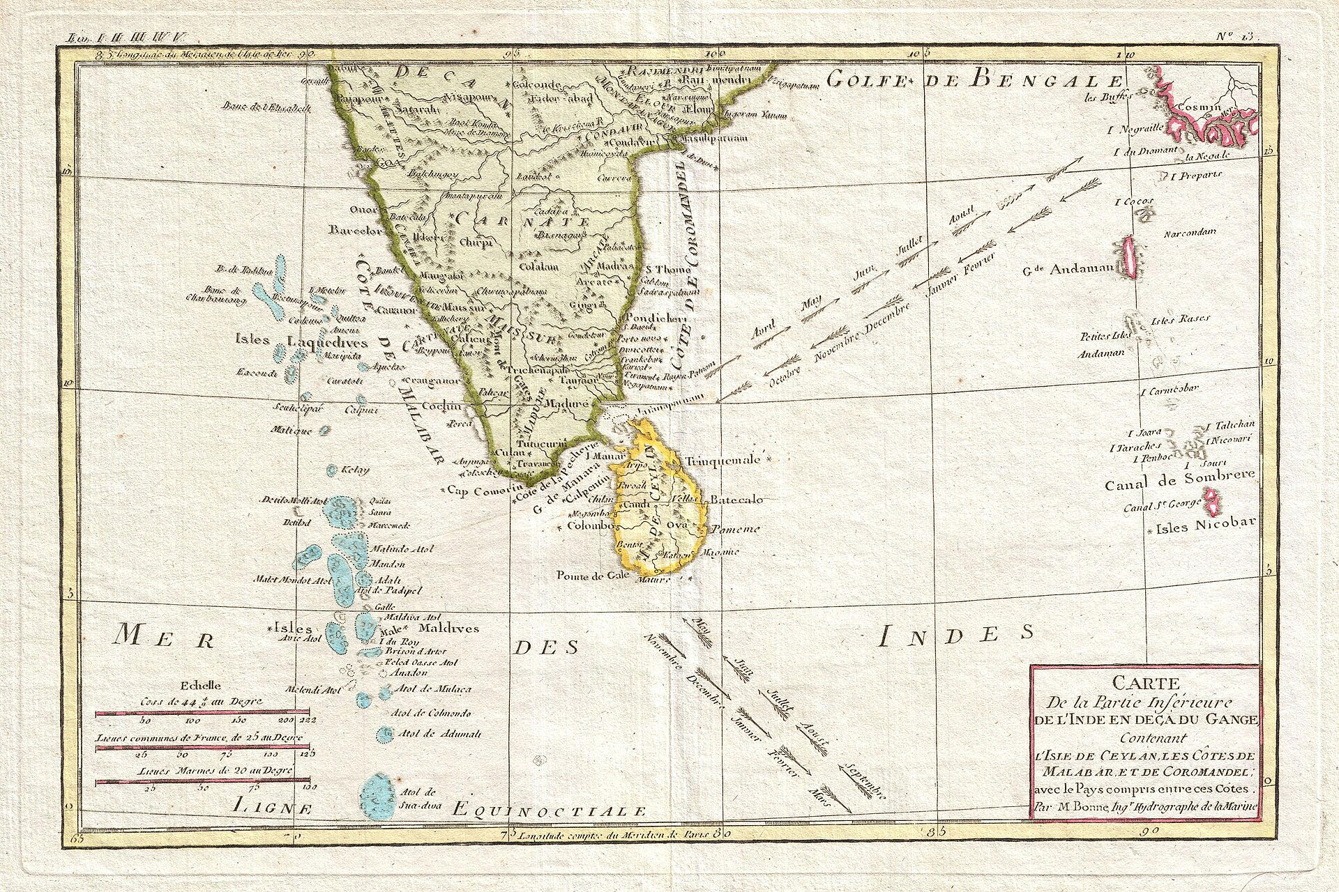
For merchants crossing the medieval Indian Ocean, the wind was not merely weather. It was a calendar. Sailors knew that seasonal monsoons could carry a vessel in one direction for part of the year and bring it back when the winds reversed. That dependable rhythm helped create one of history’s largest zones of exchange, linking the ports of East Africa and Arabia with India, Sri Lanka, Southeast Asia, and southern China.
This maritime world had no single capital and no empire controlled all of it. Its strength came from many coastal societies learning how to cooperate across distance. Merchants transferred cargo from ship to ship, brokers negotiated in multilingual markets, and rulers protected ports because customs revenue mattered. Alongside ivory, gold, spices, ceramics, and cloth traveled beliefs, technologies, artistic styles, crops, and families. The result was not a loose collection of isolated voyages, but a durable system that shaped societies around an entire ocean.
Why the Monsoon Made Long-Distance Trade Possible
The word monsoon refers to a seasonal reversal in prevailing winds, produced by differences in the way land and sea heat and cool. In the western Indian Ocean, winds generally blow from the southwest during the Northern Hemisphere summer and from the northeast during the winter. Conditions vary by region, and sailing remained hazardous, but the broad pattern was predictable enough to organize commercial travel.
That predictability reduced uncertainty. A captain leaving the Arabian Peninsula or East Africa could plan an eastward voyage around the favorable season, remain in an Indian port while trading and repairing the ship, and return on the reversing winds. Voyages still demanded deep local knowledge of currents, reefs, storms, and harbors. The monsoon did not make the ocean safe; it made movement across it more regular.
Waiting was built into the system. Merchants might spend months abroad before the return wind arrived. These long stays encouraged them to rent property, use local credit, learn languages, worship in port communities, and form personal relationships. Seasonal wind therefore had a social consequence: temporary visitors often became residents, and commercial outposts grew into multicultural neighborhoods.
An Ocean Network Older Than the Medieval Era
Indian Ocean exchange was already ancient by the medieval period. Austronesian-speaking seafarers moved across island Southeast Asia and reached Madagascar, leaving a lasting linguistic and agricultural legacy off the African coast. Greek and Roman-era texts described trade with Red Sea, Arabian, and Indian ports. South Asian merchants participated in routes that carried religions and artistic traditions toward Southeast Asia.
Between roughly 600 and 1500, however, the network expanded in scale and density. The growth of powerful states, prosperous cities, and commercial institutions around the ocean increased demand for distant goods. Islamic rule across much of the Middle East connected Red Sea and Persian Gulf ports to markets stretching through North Africa and the Mediterranean. Tang and Song China became major producers and consumers within Asian trade. South Asian ports served as crucial middle points rather than merely endpoints.
This sea-based system complemented overland exchange. The Silk Road networks connected much of Eurasia through caravans and oasis cities, while the Persian Royal Road shows how states had long invested in communication across land. Indian Ocean shipping could move bulky cargo farther and often more cheaply, but ports depended on inland routes to gather exports and distribute imports.
The Ports That Made the System Work
East Africa and the Swahili Coast
From present-day Somalia to Mozambique, Swahili-speaking port towns connected African interiors with maritime buyers. Kilwa, Mombasa, Malindi, and other settlements developed distinctive coral-stone architecture and commercial elites. Gold from southern Africa, ivory, iron, timber, and other products moved toward the coast. Imported ceramics, glass, cloth, and beads arrived from across the ocean.
Swahili civilization was neither a foreign colony nor an isolated African development. It emerged from African communities deeply engaged with overseas exchange. The Swahili language is fundamentally Bantu, while its vocabulary reflects centuries of contact, especially with Arabic. Islam became central to many coastal towns, yet local political identities and African social foundations remained strong.
Arabia, the Red Sea, and the Persian Gulf
Ports on the Arabian Peninsula occupied strategic positions between the ocean and inland markets. Aden guarded an approach to the Red Sea and benefited from traffic bound for Egypt and the Mediterranean. Persian Gulf ports linked maritime commerce to cities in Iraq and Iran. Merchants from these regions established wide networks of trust, partnership, and credit.
Commercial success depended less on carrying one cargo from origin to destination than on coordinating many exchanges. A shipment could change owners several times. Pepper from India might pass through an Arabian port before reaching Egypt; Chinese ceramics could arrive in an East African household through multiple intermediaries. Every transfer created work for sailors, brokers, money changers, porters, shipbuilders, and tax officials.
India at the Center
The Indian subcontinent occupied the network’s geographic and commercial center. Gujarat on the northwest coast became famous for textiles and entrepreneurial merchant communities. The Malabar Coast supplied pepper, one of the most sought-after commodities in Afro-Eurasian trade. Ports on India’s eastern coast linked Bay of Bengal routes with Sri Lanka and Southeast Asia.
India’s role was not simply to export valuable goods. Its ports functioned as clearinghouses where cargoes were assembled, divided, financed, and redirected. Cotton textiles were especially important because they were useful, portable, and produced in many grades for different markets. Indian cloth reached consumers from Southeast Asia to East Africa, sometimes becoming part of local systems of status and exchange.
Southeast Asia and China
At the eastern end of the ocean, the narrow Strait of Malacca became a critical passage between the Indian Ocean and the South China Sea. States such as Srivijaya prospered partly by serving and taxing maritime traffic. Southeast Asian forests and islands supplied aromatics and spices, while regional ports connected local producers to distant consumers.
Chinese demand and production added enormous weight to the system. Ceramics survive in archaeological sites across the Indian Ocean because they traveled widely and endured after many organic goods disappeared. During periods when Chinese shipping expanded, large vessels sailed into Southeast Asian and Indian waters. Even when political restrictions changed direct participation, intermediaries kept goods moving.
What Traveled Besides Luxury Goods
Famous commodities can make premodern trade appear to have served only elites. Spices, fine ceramics, and precious metals certainly mattered, but ships also carried timber, grain, dates, ordinary cloth, and building materials. High-value goods justified long voyages, while bulk products supplied cities and regional markets. Cargoes were diverse because merchants managed risk: a vessel dependent on one product was vulnerable to changing prices or damaged goods.
Plants and foodways moved as well. Sugar cultivation, citrus varieties, rice, coconuts, bananas, and other crops spread through complicated processes that unfolded over centuries. No single route explains every transfer, but sailors, migrants, farmers, and merchants collectively reshaped environments and diets around the ocean.
Religions traveled through the same ports, though conversion was never a simple by-product of commerce. Muslim merchant communities helped establish mosques and scholarly ties around the coasts of Africa, India, and Southeast Asia. Hindu and Buddhist ideas had earlier moved through South and Southeast Asian maritime networks. Beliefs were adopted, translated, and blended within local political and cultural settings rather than copied unchanged.
Trade Without a Single Ruler
The Indian Ocean system challenges the idea that extensive commerce requires one dominant empire. States mattered: they secured harbors, standardized taxes, issued currency, settled disputes, and sometimes used naval force. Yet authority remained fragmented. A merchant could pass through territories ruled by African city-states, Arabian dynasties, Indian kingdoms, Southeast Asian sultanates, and Chinese emperors during the commercial life of a single cargo.
Trust bridged those political borders. Family firms, religious communities, written contracts, reputation, and local brokers helped strangers conduct business. Merchants often relied on partners abroad rather than traveling through the entire network themselves. Diaspora communities offered lodging, information, credit, and introductions, but they also adapted to local law and custom.
The system was resilient precisely because it had many centers. The decline of one port could redirect trade to another. Political conflict or changing river channels might damage a city without ending ocean-wide exchange. This distributed structure resembles the trans-Saharan connections that enriched the Mali Empire and its trading cities: geography created opportunities, but institutions and human relationships turned routes into lasting networks.
A Brief Timeline of Expansion
- Before 600: Ancient African, Arabian, South Asian, and Austronesian mariners establish long-distance routes and settlement links.
- 600–900: Expanding Islamic commercial networks strengthen connections among the Persian Gulf, Red Sea, East Africa, and India.
- 900–1200: Swahili towns grow, South Asian textile trade flourishes, and Chinese economic expansion increases maritime exchange.
- 1200–1400: Dense routes connect East African gold, Indian manufactures, Southeast Asian spices, and Chinese ceramics through major port cities.
- 1400s: Voyages associated with the Ming admiral Zheng He demonstrate the scale of existing routes; Portuguese mariners arrive near the century’s end and attempt to force themselves into an already mature system.
Why It Still Matters
The medieval Indian Ocean reveals that globalization did not begin with modern European expansion. Centuries earlier, African, Arab, Persian, Indian, Southeast Asian, and Chinese communities had built an interconnected economy based on environmental knowledge, negotiated trust, and cultural adaptation. Europeans who entered the ocean around 1500 encountered established ports, experienced sailors, sophisticated markets, and powerful states—not an empty commercial space waiting to be connected.
The network also offers a useful way to understand how geography and institutions interact. The monsoon provided a recurring opportunity, but wind alone created nothing. People had to develop ships, harbors, contracts, navigational knowledge, and customs that made exchange possible. Technology and environment set conditions; social cooperation transformed them into a system.
Modern shipping routes still pass many of the same strategic coasts and straits. Today’s global economy uses container vessels and digital logistics rather than stitched-plank dhows and seasonal market calendars, yet it remains dependent on ports, chokepoints, predictable conditions, and networks of trust. The medieval ocean matters because it shows both the durability of interconnection and the many societies that shaped it long before the rise of modern empires.
Featured image: Rigobert Bonne’s 1780 map of southern India, Sri Lanka, and the Maldives, showing seasonal Indian Ocean trade-wind directions. Source: Geographicus via Wikimedia Commons. Public domain.
