
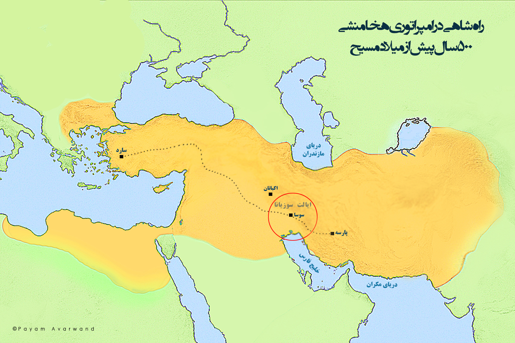
At its height in the fifth century BCE, the Achaemenid Persian Empire stretched from the Aegean coast and Egypt to Central Asia and the Indus frontier. Its rulers governed lands with different languages, religions, political traditions, and landscapes. Conquest could bring such a territory under one crown, but conquest alone could not keep it functioning. Orders had to travel, taxes had to be recorded, provincial officials had to report, and the court needed reliable information from places many weeks away.
The Persian Royal Road helped solve that problem. Best known for the route linking Susa in southwestern Iran with Sardis in western Anatolia, it formed part of a broader network of roads, stations, river crossings, and administrative centers. The road did not create long-distance movement from nothing; merchants, armies, and local communities had crossed these regions for centuries. The Achaemenid achievement was to connect and support important routes on an imperial scale.
An Empire Built Across Enormous Distances
Cyrus II, known as Cyrus the Great, founded the Achaemenid Empire in the sixth century BCE. His successors expanded it into a vast political system. By the reign of Darius I, who ruled from 522 to 486 BCE, the empire included wealthy cities, agricultural plains, mountain corridors, deserts, and major ports. Darius organized this diversity through provinces commonly called satrapies, supervised by officials who represented royal authority.
Distance was the central administrative challenge. A decision made at Susa or another royal center was useful only if it could reach a provincial governor. Likewise, the king needed reports before local crises became imperial disasters. The court also moved between major residences, including Susa, Persepolis, Babylon, and Ecbatana. Roads therefore served government itself, linking royal centers to provincial capitals and strategic frontiers.
This was not a modern nation-state with uniform institutions everywhere. Achaemenid kings often ruled through existing elites and allowed communities to retain many local customs. That flexibility reduced the need to remake every society, but it increased the importance of communication. The empire depended on negotiated loyalty, accurate reporting, and visible royal power. Infrastructure made those relationships practical.
What Was the Royal Road?
The most famous description comes from the Greek historian Herodotus, who wrote about a route between Sardis and Susa. His account lists stopping places and describes a journey of roughly 13,500 stadia. Converting ancient measurements is not exact, but the route is generally understood to have covered about 2,500 kilometers, depending on the reconstruction.
From Sardis, the road crossed Anatolia, passed through Cilicia, continued toward northern Mesopotamia, and then turned southeast toward Susa. Rivers and mountain passes shaped its course. Travelers encountered bridges, ferries, guarded sections, and stations where authorized messengers could obtain fresh horses and provisions.
It is misleading, however, to imagine one isolated paved highway. The celebrated Sardis–Susa road was a major corridor within a larger imperial system. Other routes connected Mesopotamia with Egypt, Iran with Central Asia, and the royal heartlands with the eastern provinces. Many segments followed older paths developed under Assyrian, Babylonian, Anatolian, and local powers. Persian administration brought these inherited routes into a more integrated network.
The Imperial Relay System
The road’s most remarkable feature was the royal courier service, often associated with the Old Persian term pirradaziš. Relay stations allowed official dispatches to move by changing riders or horses along the route. Instead of forcing one exhausted messenger and animal to complete the entire journey, the system divided it into manageable stages.
Herodotus praised these couriers for continuing through snow, rain, heat, and darkness. His famous description later inspired the unofficial creed associated with the United States Postal Service. The ancient service was not a public postal network in the modern sense. Access was tied to the king and administration. Its purpose was to accelerate official information, not to deliver ordinary personal letters across the empire.
Even so, its political importance was immense. A governor who knew that reports could reach the court relatively quickly operated under closer supervision. Royal orders could be distributed with greater consistency, while intelligence about unrest, military movements, or harvest conditions could travel in the opposite direction. Speed strengthened authority because it narrowed the delay between an event and an imperial response.
More Than Messages: Trade, Taxes, and Movement
Although the network primarily served imperial needs, roads rarely benefit only governments. Merchants could use secure and well-traveled corridors, even if their pace was slower than that of royal couriers. Soldiers, diplomats, craftspeople, pilgrims, laborers, and provincial delegations also moved through the same connected landscape.
The empire collected tribute and taxes in many forms, including precious metals, livestock, agricultural goods, and manufactured products. Roads helped move these resources toward administrative and royal centers. They also supported the movement of officials who assessed obligations, inspected provinces, or delivered records. Administrative documents from Persepolis reveal a highly organized world in which travelers received rations according to authorization and status.
Better connectivity encouraged exchange between regions that remained culturally distinct. Artistic styles, technologies, luxury goods, plants, and administrative practices circulated across imperial space. Persian court art itself combined influences from several subject peoples while presenting them within a coherent royal vision. Roads were not the sole cause of that exchange, but they provided channels through which people and objects could travel.
How the Road Helped the Persians Govern Diversity
Achaemenid rule did not depend on erasing every local identity. Royal inscriptions emphasized the king’s command over many lands and peoples, while provincial government often adapted to local conditions. Aramaic served widely as an administrative language, helping officials communicate across linguistic boundaries, but other languages continued in use.
The road network supported this combination of diversity and coordination. Provincial elites could remain rooted in their own societies while also participating in a larger imperial structure. Envoys and tribute delegations traveled toward royal centers. Inspectors and messengers traveled outward. The road made the king’s authority present without requiring the king to be physically present everywhere.
Infrastructure also carried symbolism. A maintained route, a protected station, or an official passport demonstrated that the empire could organize resources over distance. Travelers encountered not only geography but institutions. The network turned an abstract claim—rule over many lands—into a repeated administrative experience.
Limits and Misconceptions
The Royal Road should not be romanticized as a perfectly controlled ancient motorway. Travel remained difficult and dangerous. Weather, terrain, local conflict, and the condition of animals could all cause delays. Most people did not move at courier speed, and some imperial regions were connected more effectively than others.
Nor was every road a Persian invention. The Achaemenids inherited routes and administrative knowledge from earlier states. Their distinction lay in combining, maintaining, and using such assets across an exceptionally large empire. This pattern—adapting earlier systems rather than building every institution from the ground up—is one reason the empire proved durable.
Finally, Herodotus wrote from a Greek perspective and several decades after the reign of Darius I. His account is invaluable but must be read alongside archaeology, inscriptions, and administrative tablets. The broad picture of an organized communications network is secure, while exact itineraries and travel times remain subjects of scholarly discussion.
From Persian Roads to Later Imperial Networks
When Alexander of Macedon conquered the Achaemenid Empire in the late fourth century BCE, he advanced through a landscape already shaped by Persian routes and administrative centers. Successor kingdoms continued to depend on long-distance corridors. Later powers, including the Parthians and Sasanians, governed many of the same strategic zones, while Roman roads became famous farther west.
The Persian system was not a simple blueprint copied unchanged by every later empire. Yet it demonstrated a recurring principle of world history: large states require networks as much as armies. Roads allow power to move. Stations and documents make that movement predictable. Information gives rulers the ability to coordinate distant officials, while trade and cultural contact often follow the routes government supports.
Why It Still Matters
The Royal Road matters because it reveals what empires actually need after conquest. A map may show a ruler’s territory in a single color, but borders alone do not explain how millions of people were governed. The practical foundations of power are often less dramatic: reliable transport, standardized procedures, trusted messengers, stored supplies, and officials who can communicate across languages.
Its history also offers a useful way to understand modern infrastructure. Roads, railways, fiber-optic cables, ports, and data centers are not neutral lines on a map. They shape which places can exchange goods and information quickly, which authorities can respond to events, and which communities become central or peripheral. The technology has changed, but connectivity still influences political and economic power.
The Achaemenid network also reminds us that globalization has deep roots. Ancient connectivity was slower, uneven, and far more limited than today’s, but people across western Asia already lived within systems that linked distant courts, markets, and cultures. The Royal Road did not merely cross the Persian Empire. It helped make such a vast and diverse empire governable.
Explore More Global History
For another look at how long-distance networks transformed societies, read How the Silk Road Changed World History. To explore how interconnected systems can also become vulnerable, see Why the Bronze Age Collapse Still Matters.
Featured image: Map of the Achaemenid Royal Road by PayamAvarwand, via Wikimedia Commons. Dedicated to the public domain under CC0. The map is used as a modern visual reconstruction, not as a contemporary ancient document.